
NASA’s Curiosity Mars Rover has recently sent back a breathtaking panoramic image from the Red Planet’s surface, offering humanity a glimpse of an alien world that holds surprising echoes of landscapes found right here on Earth, while also hinting at a watery past. This incredible view from Mount Sharp inside Gale Crater not only reveals the rugged beauty of Mars but also provides crucial clues about how the planet transformed from a potentially habitable world into the dry desert we see today.
Contents
Gazing Across Gale Crater
Imagine standing on a mountainside in a vast, ancient impact crater. That’s essentially the vantage point of the Mars Curiosity Rover when it captured this stunning panorama. The robot explorer is currently climbing the slopes of Mount Sharp, a towering peak within Gale Crater, a massive bowl formed billions of years ago by an asteroid collision.
The view stretches out across the crater floor towards the distant horizon. Those aren’t mountains in the background, but the very rim of Gale Crater itself, rising up from the impact. The landscape is a tapestry of rocky terrain, layered hills, and dusty plains, sculpted by wind and time. NASA adjusted the image colors to approximate how the scene would appear under Earth’s lighting, making the rust-colored landscape feel strangely familiar.
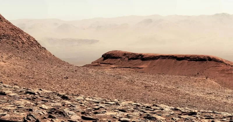 Detailed view of rocky Martian terrain and layered hills within Gale Crater captured by the Curiosity rover.
A Scene Reminiscent of Earth?
Early photographers captured the raw, untamed beauty of places like the Sierra Nevada and Yosemite. This panorama from Curiosity on Mars, remarkably, evokes a similar feeling of pioneering discovery, presenting a vista that bears a certain resemblance to rugged, arid regions of the American Southwest. It’s a powerful reminder that while alien, other planets can hold visual parallels to our home world.
Why This View Matters
Beyond its striking beauty, this Martian landscape is a treasure trove for scientists. Mount Sharp, which Curiosity is steadily ascending, is made up of layers of rock deposited over eons. Within these layers, scientists have found evidence of salty minerals. Think of these minerals like the residue left behind when a puddle dries up – but on a planetary scale. They are strong indicators that streams and ponds once flowed across the floor of Gale Crater billions of years ago.
By studying these mineral-rich layers and the geology revealed in panoramas like this one, the Curiosity team is working to unravel one of the biggest mysteries about Mars: how and why did it change from a potentially wet and warm world to the cold, dry desert it is today? Every rock analyzed and every image captured adds another piece to this ancient puzzle.
NASA even created a captivating 30-second video panning across this image, allowing viewers to virtually stand on Mars and take in the scene. Watching it, you can almost imagine the thin Martian wind or the gentle lapping of waves on an ancient lakeshore, ghosts of a bygone era on the Red Planet.
The Search Continues
The work of the Mars Curiosity Rover is far from over. As it continues its slow climb up Mount Sharp, it will keep examining different layers of rock, searching for more clues about Mars’ watery past and its climate evolution. Each panorama it sends back is not just a stunning photograph; it’s a scientific dataset, a window into another world, and a step forward in our quest to understand the history and potential for life beyond Earth.
To see more incredible images from Mars and learn about the rover’s ongoing mission, explore the latest updates from NASA’s Jet Propulsion Laboratory.