
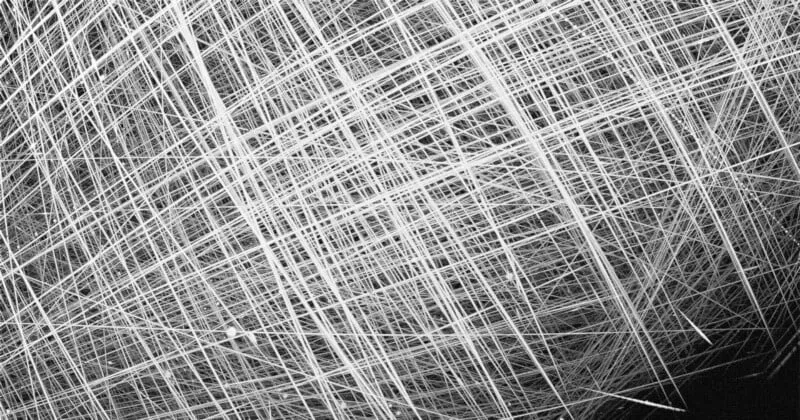
Imagine looking up at the night sky, not seeing stars, but a tangled web of white lines. That’s exactly what a groundbreaking new image reveals over the Arctic: a dramatic visual of the sheer number of satellites circling our planet, captured for the first time in such detail. This image, showing every satellite streak visible in a specific part of the Arctic sky on a single night, highlights the growing congestion in Low Earth Orbit and the need for sophisticated satellite tracking. Key takeaways include a never-before-seen visual representation of orbital traffic, the development of a low-cost, all-sky monitoring system, and insights into the impact of mega-constellations on our view of space.
Contents
Capturing the Cosmic Highway
For one night in February 2025, researchers pointed their cameras towards the Arctic sky above Eureka, in Canada’s Nunavut territory, and captured something extraordinary. Instead of just spotting stars or the occasional meteor, their long-exposure photo looks like a busy highway lit up at night. Every white streak you see is the path of an individual satellite zipping across the sky as the cameras watched.
 White streaks crisscrossing a dark sky, showing the paths of multiple satellites captured over the Arctic in a single image.
This striking composite image, built from data from 14 different cameras, is the first-ever picture to show all the satellite streaks detected in one patch of the Arctic sky on a specific night. It offers a powerful, visual reminder of just how many objects are now orbiting Earth, especially over the poles where many satellite paths converge.
How Do You Track Every Satellite?
Creating such a comprehensive image wasn’t easy. A team from Western University in Canada, working with Defense Research and Development Canada, adapted techniques usually used for tracking meteors. They deployed 14 low-cost cameras strategically placed to monitor the entire sky at once.
These cameras are special because they are highly sensitive and can capture images dozens of times every second. This allows them to track fast-moving objects not just like meteors, but also the rapidly increasing number of satellites and even space debris in Low Earth Orbit (LEO), the region below 2,000 kilometers altitude.
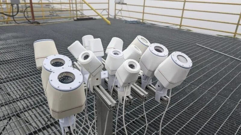 Multiple cameras mounted on a platform under a grey sky, used for tracking satellites in the Arctic.
The system is designed to be relatively inexpensive yet powerful, capable of detecting objects larger than 30 centimeters. This isn’t just a one-off experiment; the system is now part of a larger network deployed at four locations across Canada, providing continuous, year-round satellite tracking data.
Monitoring Our Crowded Skies
Why is this level of monitoring so important, especially in the Arctic? With the rapid launch of thousands of satellites for “mega-constellations” like Starlink, Low Earth Orbit is becoming increasingly crowded. This congestion poses challenges for everything from astronomy and space research to simply enjoying a view of the night sky.
Peter Brown, Canada Research Chair in planetary science at Western University, emphasizes the urgency: “The rapid proliferation of mega-constellations of satellites… make it an urgent priority for Canada to have its own capabilities to persistently monitor wide swaths of space above the country.”
The new system provides Canada with sovereign capability to monitor its airspace and gain a better understanding of the current state of the space environment.
So far, this network has made nearly half a billion individual observations and tracked over 17,000 distinct satellites. It regularly monitors over 90% of all active satellites in LEO passing over Canadian territory.
Beyond just tracking location, the researchers are also studying how bright these satellites appear. This data helps assess their impact on stargazing and astronomical observations. The team hopes to make this brightness data for mega-constellations publicly available in Canada in near real-time soon, allowing anyone to see how satellite traffic might affect their view of the cosmos.
What Comes Next?
This striking image and the sophisticated tracking system behind it provide crucial data in an era of rapidly increasing space activity. By showing us exactly what’s filling our skies, researchers are highlighting the need for better monitoring and understanding of Low Earth Orbit.
The ongoing work aims to not only track objects for safety and awareness but also quantify the impact on our ability to see the stars. As space becomes more crowded, initiatives like this are vital for managing orbital traffic and protecting the natural wonder of the night sky for future generations.